September 2025 Newsletter
Added at 19:26 on 19 October 2025
The Highland Geological Society September 2025 Newsletter
Scottish Charity No. SC004427
I hope all members have enjoyed a good summer season with mostly good weather allowing virtually all of our excursions being held in pleasant conditions. This autumn HGS newsletter will give details of forthcoming lectures, a brief outline of proposed field trips for 2026 and end of season report on HGS activities during 2025. This year we have 4 authors for the field trip reports, Dave Longstaff, Alan Thompson, David Rae and Dr Martin Smith, thank you all for this group effort.
HGS transition to a Scottish Charitable Incorporated Organisation (SCIO)
With a huge thank you to the committee and especially Karen, Kathryn and Alan we are finally near the end of the process of changing the charitable status of the HGS from OSCR to a Scottish Charitable Incorporated Organisation (SCIO) and this will take effect from 1st October. In this process we have changed our bank account and have had to update our constitution but HGS activities and day to day running of the society will remain the same.
HGS Christmas Quiz. Early days yet but there plans to hold a HGS Christmas Quiz on Zoom on Tuesday 16thDecember. Watch this space!
2025/26 HGS lectures. Inverness Youth Hostel or on Zoom. Lectures are normally held on Wednesday evenings starting at 1930 although please note that Prof John Howe’s lecture currently stands as Thursday 19th Feb.(Zoom).
2025
8th Oct. James Ryan (NTS): Hugh Miller (hybrid)
12th Nov. Romesh PalamakUMbuara. (BGS): Great Geln Fault (hybrid)
10th Dec. Dr Maartin Krabbendam (BGS): The Moine no more (Zoom)
2026
14/21st Jan. Date tbc. Dr Mike Simms (National Museums NI): Carnian pluvial episode (Zoom)
19th Feb. Prof John Howe (SAMS): Sea bed mapping (Zoom)
18th March. Dr Nick Gardner (University of St Andrews): Battery Metals (hybrid)
Proposed field trips 2026
Strathnairn: Ann and Peter Reynolds late spring/early summer
Portsoy: Sat 23rd May. Prof John Parnell
Lochindorb: Dr Martin Smith summer/autumn. Needs to avoid nesting season and alternative/additional venues.
Tarbatness/Portmahomack. Sat 19th Sept.: Dr Steven Andrews
Quarrywood, Elgin: tba Dave Longstaff
Ken Glennie Conference Fri 8th-Sun 10th May. Arranged by Aberdeen Geological Society there will be a conference in Aberdeen 8th May and proposed field trips around Elgin and Hopeman Sat 9th and Sun 10thMay.
2025/26 HGS lecture abstracts.
8th Oct. James Ryan (NTS): Hugh Miller (hybrid)
Fossil hunter, folklorist, man of faith, stonemason, geologist, editor, writer and social justice campaigner – Hugh Miller was one of the great Scots of the 19th century. He has been acclaimed as "the supreme poet of geology" and called "the David Attenborough of his day." He gained such accolades not only as a pioneer of the science in its first heyday, but because he wrote about everything he saw and discovered in such delightful terms. To celebrate the 223rd birthday of this incredible man, join James Ryan from the Hugh Miller's Birthplace Museum for a talk all about the life and legacy of Hugh Miller.
12th Nov. Romesh Palamakumbura (BGS): Great Glen fault (hybrid)
Pumped storage hydropower projects are of vital importance to the reliable decarbonisation of the future electricity provision in the UK. These typically involve construction of tunnels and underground cavern and hence, geological factors can play a significant role in their design and construction. The British Geological Survey (BGS) has provided impartial geological expertise and knowledge during the ground investigations of several major hydropower projects with clients across the UK. This involves providing an in-depth understanding of geological features from micro-scale processes to larger-scale regional geological controls. A robust understanding of the site-scale geology supports a more in-depth and accurate geotechnical characterisation of the rock mass including features that may impact rock strength, such as fault and fracture networks or hydrothermal alteration processes. Working in close collaboration with engineering geology consultants, such as to provide a better understanding of the site-scale geology can support a more focussed ground investigation phase and most importantly will further derisk future proposed pumped storage hydropower projects.
10th Dec. Dr Maarten Krabbendam (BGS): The Moine no more: A new stratigraphic framework for the early Neoproterozoic successions of Scotland. (Zoom)
The advent of modern dating techniques has in the last decades provided much better timing constraints on the deposition of Neoproterozoic sequences (1000-550 Ma) in Scotland, in Greenland and Svalbard. This has shown that the Neoproterozoic evolution of this north Atlantic province is dominated by three tectonic episodes: the Grenville-Sveconorwegian orogeny, the Renlandian orogeny and the rifting and formation of the Iapetus Ocean. In Greenland and Svalbard, Neoproterozoic sedimentary rocks can be divided into three ‘megasequences’, constrained by the three major tectonic episodes. In northern Scotland, however, the classic subdivision of Torridonian and Moine is at odds with these megasequences: new stratigraphic framework is thus necessary.
The oldest megasequence in Scotland is the newly named Wester Ross Supergroup, comprising the Iona, Sleat, Torridon and Morar groups of the Scottish mainland and Inner Hebrides, and the Westing, Sand Voe and Yell Sound groups in Shetland. These units were deposited c. 1000–950 Ma within a foreland basin to the Grenville Orogen.
The second megasequence is the newly named Loch Ness Supergroup consists of the Glenfinnan, Loch Eil and Badenoch groups of the Scottish mainland. These units were deposited after the Renlandian orogeny between c. 900–870 Ma and record Knoydartian orogenesis c. 820-725 Ma.
The Dalradian Supergroup in the Grampian Highlands and Shetland belongs to the third megasequence: it was deposited c. <725-500 Ma and records the opening of the Iapetus Ocean, ultimately leading to deposition of the passive margin Cambrian-Ordovician Ardvreck and Durness groups in the NW Highlands.
14/21st Jan. Dr Mike Simms (National Museums NI): Carnian pluvial episode (Zoom)
Details to follow.
19th Feb. Prof. J.A.Howe (Scottish Association for Marine Science: SAMS). Sea bed mapping. (Zoom)
John is a marine geologist with the Scottish Association for Marine Science and the University of the Highlands and Islands (UHI). This talk explores the development of seabed mapping and its application for marine geoscience. The talk will mainly focus on the Firth of Lorn, western Scotland and will examine the region’s submarine solid and late glacial geology and geomorphology, including the famous Gulf of Corryvreckan. In addition, the use of autonomous underwater vehicles to map the glacial environments of Svalbard and Greenland will be described.
18th March. Dr Nick Gardner (University of St Andrews): Battery metals - and the race to net zero. (hybrid)
The transition to a renewable energy system for the generation, transmission, and storage of electricity, requires an unprecedented supply of key metals, in particular so-called “battery metals” tin, lithium, tungsten, and tantalum. These metals are primarily sourced from magmatic-hydrothermal deposits, most notably small-scale deposits known as pegmatites.
Here, we discuss how in a global mining context these battery metals are relatively minor, with a fragile supply pipeline. We discuss the current rush for lithium, and focus on current research on lithium pegmatites: how new geochemical tools can help shed light on the processes of mineralization, to help us build better models for the formation and discovery of these enigmatic deposits.
HGS summer field trips reports.
Saturday 3rd – Saturday 10th May: Kintyre and Gigha. Self-led trip arranged by Ann Reynolds. Report and photos: Alan Thompson
Ann and Peter Reynolds had the idea for this self-led week, and undertook all the necessary recces, speaking to landowners, finding accommodation, etc to make it happen. The result of their efforts was a fascinating and enjoyable excursion to a part of the country we don’t usually visit. Excellent weather was provided as well, as you can judge from the photos.
Nine of us stayed in a self-catering farmhouse a little way south of Campbeltown, sharing the cost as well as necessary cooking, driving, etc. In previous years we have also shared the task of researching and leading each day, but on this occasion Ann and Peter had planned all the excursions based on their recces, GCR sites, suggestions from David Jarman, and on parts of a Geological Society of Glasgow excursion made in 1994. Some highlights from the week:
We spent two days in the island of Gigha.
Lunch stop near the south of the island
Unfinished quernstone cut-outs in amphibolite
Coal has been mined near Macrihanish, but the former mines have been closed and landscaped. We sought out the relevant rocks in Tirfergus Glen. Very overgrown and a challenge to access.
The waterfall reveals the edge of the basalt debris above the shales and coals
Evidence of actual coal!
We drove north to visit Barmore Island, a GCR site, “A representative cross section through the Dalradian rocks of the uppermost Argyll Group and the Southern Highland Group in Knapdale and north Kintyre”. Very rough shoreline. We took the offer of tea and cream cakes at the Stonefield Castle Hotel, overlooking the bay.
An excellent fish trap visible at low tide. Access to the GCR section is along the far side
Loch Tay limestone formation (at right)
At the southern tip of Kintyre (the end of the road) is the memorial to the Chinook crash in 1994. We also explored the beaches of the south coast.
View north from the Chinook memorial, RSFs and anti-scarps
At Pennyseorach beach, calcretes
. . and much more! I hope that gives a flavour of the week. Thanks again to Ann and Peter for organising it.
Wednesday 21st May: Rock Slope Failures, Cluanie. David Jarman (HGS)
Report and photos: Dave Longstaff with input from David Jarman.
A group of 9 HGS members met at the Bakehouse Café by the Cluanie Inn on a beautiful, hot and sunny day in order to view glacial and paraglacial features in Glen Shiel under the leadership of David Jarman.
We began the day by David explaining the contrast between the ‘V’ shaped lower Glen Shiel to the wider ‘U’ shaped profile near Loch Cluanie. The group were stood on glacial debris directly underneath the shapely munro Sgurr na Ciste Duibhe with a huge mound of rockslide debris separating us from a good view of the mountain. The rock slope failure cavity above this mound is better viewed from further east along Glen Shiel, the toe of this feature is responsible for the creation of the narrow Pass of Glen Shiel.
The group then moved nearer Loch Cluanie to begin the ascent of Druim Shionnaich in order to view an enormous rock slope failure at first hand. After steady ascent of 300m we rested by a stream for a lunch stop where a very inquisitive weasel obviously thought we were on his personal spot, maybe a litter was nearby? After lunch and more climbing to around 700M we were able to view the rock slope failure on the northwest flank of Druim Shionnach. The scale of the feature is very impressive with a broad faulted graben separating the main mountain mass to the antiscarp. Small lochans litter the floor of the graben and many hidden fissures to negotiate. All in all a hugely impressive sight made all the better with David’s informed commentary on all of the glacial features within view.
Rock slope debris below Sgurr na Ciste Duibhe
Lower Glen Shiel: V profile
Wide view of faulted graben: Flank of Druim Shionnach on left, antiscarp on right.
Close up of antiscarp,figures give scale. Floor of faulted graben.
Tuesday 3rd -Wednesday 4th June: Grampian Shear Zone, Dr Martin Smith
Report and photos: Dave Longstaff.with comments Martin Smith
3rd and 4th June: unconformities in the Central Grampian Highlands, the River Findhorn and Kincraig. Dr Martin Smith
10 members met at Randolph’s Leap by the River Findhorn, Forres, in readiness for a 2-day excursion led by Dr Martin Smith. The plan was to examine the unconformable relationships between the Neoproterozoic Badenoch Group which forms the basement to the Grampian Group cover rocks which in turn are overlain by Devonian conglomerates and sandstones as revealed in the River Findhorn gorge.
In the River Findhorn, upstream of Randolph’s Leap, Grampian Group metasediments made up of siliceous psammites and quartzites of the Nethybridge Psammite Formation rest on basement gneisses. Outcrops on the southeast bank, easily accessed from a fishers path, expose the contact zone though the actual unconformity surface proved difficult to pin down and elicited much conversation. At Randolph’s Leap and with low River Findhorn water levels we were able of examine at first hand excellent water washed exposures the Nethybridge Psammite Formation showing clearly inverted bedding, granitic veins and locally migmatitic neosomes deformed by a two phases of D2/D3 Caledonian folds. The psammites also intruded dark garnet amphibiltic intrusive sheets and dykes. Downstream, below the Mains of Sluie cottage we explored beautiful exposures of Old Red Sandstone (Mains of Sluie Conglomerate Formation) lying unconformably on the Nethybridge psammites.
Inverted Nethybridge psammites, HGS group on sandstone conglomerates
River Findhorn basement psammites are under water. .
The following day we regrouped near Kincraig House in order to climb the modest hill, An Suidhe, to examine Grampian Group metasediments lying unconformably on Badenoch Group basement rocks which also host the Grampian Shear Zone. This GCR site much studied and previously used by BGS for mapping training is now quite overgrown and the upper parts of the succession are obscured by vegetation and a forestry plantation. Our group hunted down fairly small exposures of Badenoch Group gneissose semipelites and micaceous psammites with recumbent folds in the core of a large antiform. Towards the top of the gneisses the mid-crustal Grampian Shear Zone is patchily exposed with a series of granitic pegmatites dated at c. 810-800 Ma confirming that the basement rocks are affected by the Knoydartian Orogeny. Above the gneisses a sheet of garnet amphibolite separates these rocks from the Grampian Group. At Kincraig the basal unit of the Grampian Group (Kincraig Formation) is distinct and contains units of calc-schist and metalimestone. Upslope two large lime kilns were explored and on clean surfaces in a nearby quarry thinly banded rythmites were beautifully displayed. These features suggest past marginal marine conditions subject to tidal variations or sea level change. The group enjoyed an interesting although a geologically challenging 2 days and thanks to Martin for leading this excursion.
Pegmatite in Badenoch psammites Rythmithcally bedded metalimestone
(Peter Reynolds)
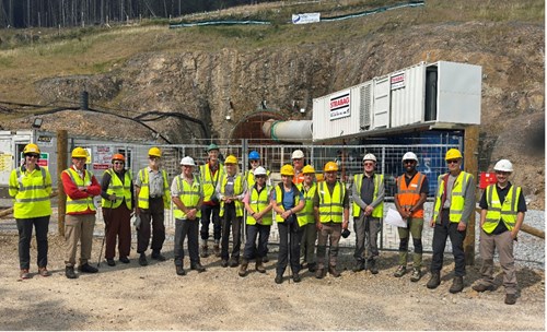
Thursday 14th August: Coire Glas hydro-scheme, Dr Romesh Palamakumbura (BGS). Report: Dr Martin Smith, photos Dave Longstaff.
On 14th August 14 members of HGS visited the SSE pump storage scheme at Coire Glas on the west side of Loch Lochy.
The day was led by Jessica Smith of SSE and Romesh Palamakumbura of BGS, the aim being to see the operation and gain insights into new discoveries related to the Great Glen Fault Zone (GGFZ). The scheme includes a storage dam located at around 500 m above sea level that feeds a steeply inclined head race tunnel down to a power cavern. With a head of c. 500 m when up and running the Coire Glas scheme will be the single largest hydroscheme in the UK with a potential capacity 1.3 GW. The fact that SSE have spent to date £100m on ground investigation alone gives an idea of the scale and complexity of the project. See Coire Glasfor further information.
The morning was spent at the portal of an 10m diameter tunnel that extends 1.2 km horizontally into the hillside. This tunnel is a key part of the ground investigation and effectively transects the west wall of the GGFZ proving a zone of complex fault geology some of which is exposed in a nearby road cutting.
A short exercise looking at fault textures and fracture patterns allowed Romesh to explain the difficulties in identifying primary layering (bedding/gneissosity) and the approach adopted by BGS geologists and SSE engineers in logging fractures and alteration in the tunnel and core. Of note are the discoveries of, a wide zone of carbonate alteration that affects the rocks for at least 700 m into the tunnel and, the presence of a major fault (thrust?) not exposed at the surface.
HGS group, with Dr Romesh Palamakumbura (BGS, third right) and Jessica Smith (SSE, far left)
A visit was also made to the spoil tips along strike which when viewed from a distance give a rough alteration ‘stratigraphy’ of the psammitic rocks encountered. After lunch the group inspected various lengths of core that highlight the variety of fracture patterns and mineralisation. The below photograph shows cataclasite and brecciated fabrics cemented by carbonate (dark grey) and cut by later hematized quartz veins. The Great Glen Fault is known to cut the moho and thus the wide zone of carbonate alteration may be linked to the serpentinites at Glen Urquhart and ultimately have a mantle source.
Our thanks to Jessica and Romesh for a fascinating day out and the rare opportunity to see some brilliant fault rock textures.
Above: Core of cataclasite and brecciated psammite cemented by calcite (dark grey) and later hematized quartz veins.
Left: Dr Romesh Palamakumbura (BGS) explaining the tunnel geology
Sunday 17th -Tues 19th August: Ballantrae, Prof Alastair Robertson (University of Edinburgh) Report: David Rae and photos except where stated.
The trip was held over three dry and sunny days expertly led by Professor Alistair Robertson and organised by Ann Reynolds. Around 19 HGS members (numbers varied day to day) assembled in the Westcliffe Hotel, Girvan, where most of the group were staying, to hear a pre-excursion geology talk by our leader Alistair. As you can imagine breakfast in the hotel resonated with lively geology talk!
The Ballantrae Ophiolite complex consists of rocks originating from the ocean floor and underlying mantle that were thrust, about 480million years ago, up onto the continental crust during the closure of the Iapetus Ocean. An idealised ophiolite sequence comprises ultramafic rocks of the mantle followed by gabbros,sheeted dykes,pillow lavas and sediments. In the Ballantrae area the sheeted dykes are missing but the pillow lavas are thicker than normal. Also, due to faulting and thrusting the complex consists of dismembered fragments of the various rock types rather than showing the rock types in sequence. On the the first day we climbed Byne Hill to view the local scenery and to examine gabbros and conglomerates with a group photo taken to celebrate the fact we’d conquered a very modest hill! On the hillside above Knockhaugh amphibole with hornblende is interpreted as being created to form a metamorphic sole when hot ocean mantle slid up over the continental crust.
Group shot: Byne Hill (Anne Burgess)
Slickensided gabbro: Byne Hill.
The ocean mantle rocks would initially have been varieties of peridotite. This has subsequently been altered to a grey green serpentinite which is frequently sheared and contains veins of fibrous chrysotile as seen at Balcreuchan Port. Moving up to the rocks of the ocean crust and floor, gabbro is exposed at Byne Hill and pillow lavas at Port Vad.
Port Vad: Pillow lavas (Dave Longstaff)
Balcreuchan: Serpentinite with fibrous chrysotile.
Finally, the ophiolite “sequence” is completed by radiolarian cherts and black shales and sandstones seen at Bennane Head.
After the ophiolite was in place, further to the south at Downan Point more pillow lavas were formed about 450 m. y. ago. These examples are amongst the best in the U.K.
Pillow lava, Downan Point.
Bennane Head: Folded Radiolarian chert.
Saturday 6th September: Nigg and Cromarty, Prof Peter Scott.
Report and photos: Dave Longstaff.
14 HGS members met at the Nigg ferry terminal on a fine Saturday to be led by Prof Peter Scott, the object being to examine the foreshore outcrops of the Raddery Sandstone Formation. A quick trip on the Nigg Ferry allowed us to explore the north side of the Cromarty Firth where we could start scrutinising the rocks. This O.R.S formation, approximately 350 million years old, consists of thin bands of sandstones, silty mudstones, limestones with carbonate concretions and as one progresses eastwards thick beds of poorly stratified conglomerates before meeting the unconformity where the underlying basement rocks are folded Moinian psammitic gneisses, roughly 800 million years old. The concretions supposedly contain fossil fish but none were seen by the group, however, concentrations of garnet sands contained in small embayments on the shoreline made up for this disappointment. On returning to Cromarty we then explored the shoreline on the south side of the firth. In stark contrast to the north side virtually all of the bedrock, including the famous Hugh Miller fish beds, was hidden by shingle and seaweed, a common occurrence. One member did find a fractured nodule displaying very nice Coccosteus scales while another member found a large limestone nodule with fragments of fish showing at the edges. Bob Davidson MBE, O.R.S fossil fish expert, identified this, from a photograph, as a beautiful example of a nodule from the Coal Heugh Burn Mouth Fishbed (CHBMF) and of much interest left just as it is in an unopened state. After an interesting afternoon most of the group reassembled for an evening meal in The Fishertown Inn, a very convivial way to end a field trip.
Garnet sands, North Sutor.
Coccosteus fossil fish, Cromarty
Items of interest, geological websites
SGT Geosite and SGT GeoGuide.
The SGT Geosite project continues apace with many Scottish SSSIs and GCR sites now covered with a photographic record. https://geosites.scottishgeologytrust.org/
The accompanying SGT GeoGuide website now has scanned versions of an incredible 173 publications including all GCR volumes, a huge resource: https://geoguide.scottishgeologytrust.org/
Orkney Science Festival YouTube channel
This channel features videos produced for the Orkney Science festival and features geology, geomorphology, archaeology and local history and is recommended.
https://www.youtube.com/watch?v=CaGCmTAfF98
Hugh Miller Cottage Museum
https://www.nts.org.uk/visit/places/hugh-millers-birthplace/
Friends of Hugh Miller
A link to the Friends of High Miller website https://www.thefriendsofhughmiller.org.uk/
The Scottish Geology Trust
http://www.scottishgeologytrust.org/
Other Scottish geological societies:
Aberdeen Geological Society
http://www.aberdeengeolsoc.org.uk/
Edinburgh Geological Society
https://www.edinburghgeolsoc.org/
Glasgow Geological Society
https://geologyglasgow.org.uk/
Open University Geology Society
https://ougs.org/
CONTACT INFORMATION:
Co-Chairs Karen Deans highlandgeologicalsociety@gmail.com
Alan Thompson alanrossthompson@hotmail.com
Secretary: Anne Cockroft hgssec@gmail.com
Treasurer: Kathryn Logan logan4ou@uk8.net